
Poor weather conditions are listed as the third most common cause of aviation accidents and crashes. Technological progress in meteorology and other fields supporting aviation, the availability of data, and rapid reporting of weather changes make the number of aviation incidents compared to the number of operations performed systematically decrease. Today, the greatest danger for pilots is the violent weather changes, for which they are not prepared.
The Institute of Meteorology and Water Management – National Research Institute, within the framework of the MOLC service, conducts ongoing weather observation at Polish airports. One of the elements of this service is the preparation of aviation forecasts and warnings – these tasks are carried out by the Aviation Forecast Offices in Warsaw and Cracow. The recipients of the messages are air traffic controllers, airport duty officers, airlines, and pilots of planes, helicopters, gliders, and balloons. Each group has a slightly different view of the dangers of weather. The surface wind of 15-20 KT (27-37 km/h) will not be an obstacle to flight for an airplane pilot; in the case of a balloon, such conditions make it practically impossible to undertake any air operations. Therefore, forecasts and warnings have different criteria and are adapted to the needs of the recipient.
In aviation, wind and turbulence are among the most dangerous phenomena related to meteorological conditions. Both problems may occur during take-offs and landings, as well as during the flight, e.g., within the range of convective clouds or through the zone of the atmospheric front. In meteorology, the wind is defined as the horizontal movement of air caused by the forces that act on it (pressure gradient force, centrifugal force, friction, and Coriolis force). A synoptic that considers the evolution of the baric field and local conditions can determine whether the wind direction, mean speed, and gusts can adversely affect flight operations. The wind direction informs us “where the wind is blowing from”, and it refers to the geographical north in most reports and meteorological maps. The exception is the wind information provided by air traffic control to pilots for take-off or landing from a specific airport. This is called a navigational wind, indicating “where the wind is blowing”, and refers to the north not geographic but magnetic.
Wind speed and direction – key parameters for flight safety
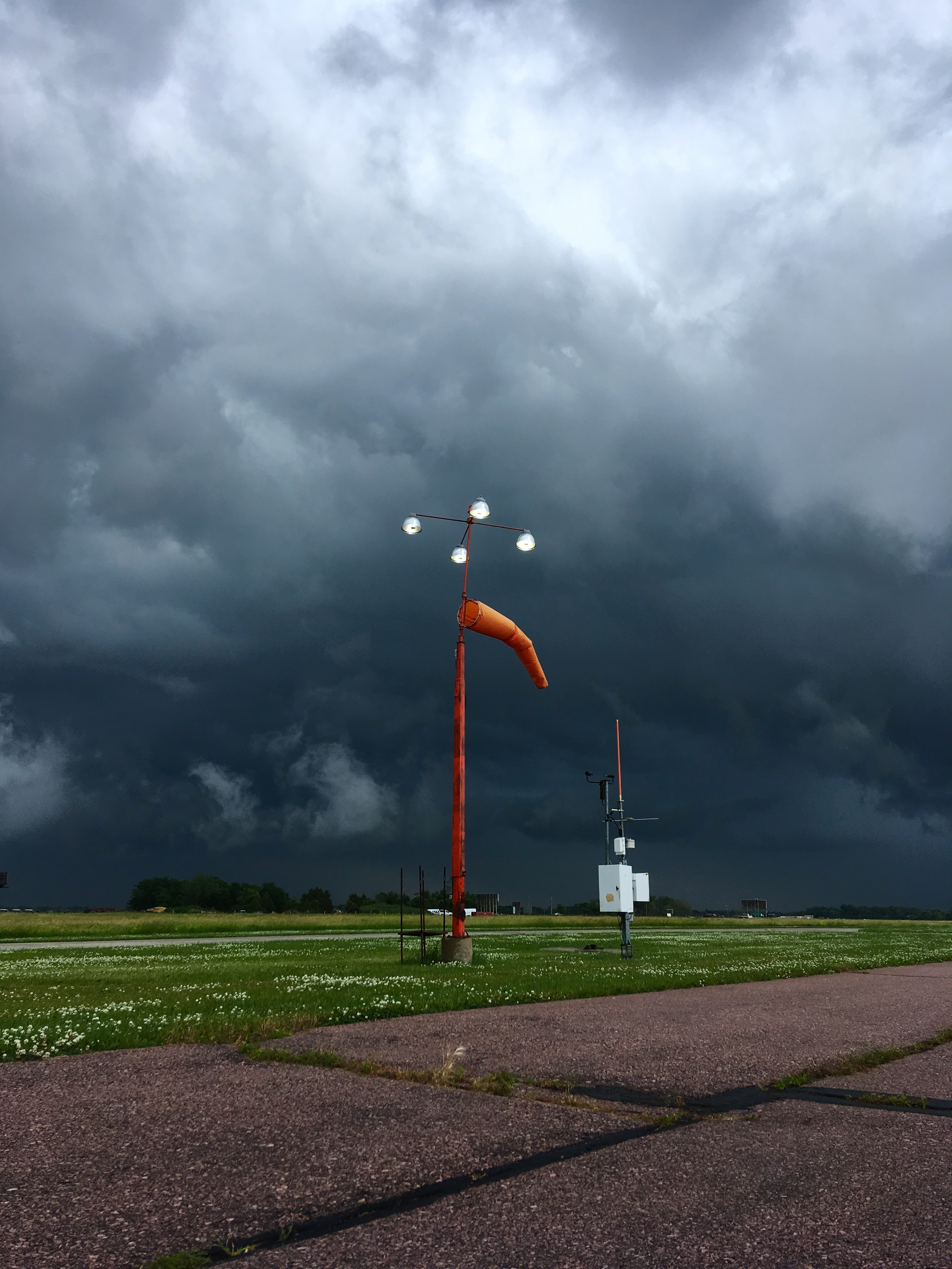
During take-offs and landings, wind speed higher than 30 KT (approximately 55 km/h) is considered dangerous. Most communication airports indicate this value as a criterion for issuing an airport warning, distinguishing between the mean wind speed and gusts. Similar criteria (25 KT for mean wind and 30 KT for gusts) apply to warnings for Helicopter Emergency Medical Service bases (HEMS). Therefore, meteorological stations send STORM² warning messages, and forecast offices issue warnings about the possibility of strong winds or gusts. The higher the wind speed, the greater the danger for flight operations. The wind direction is also significant. A common dilemma for air traffic controllers is the right choice of operating lane to minimize the impact of cross and tail winds on taking-off or landing planes. On the internet, you can find many videos showing landing with a strong crosswind. Admittedly, they look both effective and, at times, terrifying.
Other dangerous meteorological phenomena related to wind speed include:
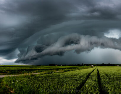
Squall. It is a sudden, short-term increase in wind speed (sometimes above 20-30 m/s), often combined with a change in its direction. Most squalls are associated with the passage of Cumulonimbus clouds, usually accompanied by showers and storms. Squalls can occur in a unstable, humid, and warm air mass or be related to cold atmospheric fronts.
Blowing snow/ blizzard/snowstorm. Its formation is related to the deposition of snow cover or snowfall combined with high surface wind speeds. When the wind speed increase, drifting snow can turn into a blowing snow – then the snow is lifted above the level of 1.5 m. Blowing snows make airport operations difficult – they create snowdrifts on the runways and make visibility worse. A blizzard forecast is based on determining the wind’s force and direction, taking into account the state of snow cover.
Sand and dust storm. Due to strong wind, it is formed when sand and dust are lifted from the dry soil surface to a significant height (above the observer’s eye level).
Wind shear – an unexpected issue
The phenomenon of wind shear has been the main or indirect cause of many aviation accidents and incidents. In such circumstances, an Airbus A320-211 plane from Lufthansa crashed at Okęcie Airport on September 14, 1993. Two people died. Aircraft crew members and General Aviation pilots must be aware of this dangerous phenomenon. When they encounter them in flight, they should collect data and pass on all related information.
A wind shear is rapid change in wind direction and/or speed. The strongest shear can cause a sudden horizontal speed change of higher than 15 KT or a vertical change of higher than 150 m/min (500 FT/min). While wind shear can occur at all altitudes, particularly severe are those that occur in the layer from the ground surface to the height of 500-600 m (1,600-2,000 FT) during aircraft take-offs and landings. The wind shear can be positive (increase in the lift) or negative (loss of lift). Imagine a ski jumper flying. When the gust under the skis significantly lengthens his jump – we are talking about an increase in the lift. When the rear gust is damping and forces the competitor to land quickly – we are dealing with a loss of lift. An airplane is only slightly faster than its limit value during take-off and landing, below which it is dragged.
If the aircraft encounters a sudden change in wind speed and/or direction at this point, it may lose some lift. If this loss is large enough and the engine power increase is insufficient, the aircraft will have a deep collapse (sudden loss of height). Whether or not the loss of height will be stopped in time and will not result in the machine crashing to the ground depends on the height at which the wind shear occurred, the pilot’s response time, and the aircraft’s flight characteristics.
Another danger of wind shear is the decrease in aircraft performance. It occurs when the plane enters a zone where headwind speed decreases in a short time. The airspeed relative to the wings then decreases, which causes the decrease of the airplane speed indicated by the instruments. Since the lift depends on the speed of the air flowing around the wings, it decreases. All these factors are very dangerous. When the plane is at a low altitude, such as when taking off or landing, its speed is low. If it encounters wind shear in such conditions, it will slow down even more and, consequently, lose flight altitude, which may result in a touchdown or crash. Similarly, wind shear is a dangerous.
It occurs when the airplane crosses the boundary between the tail and headwind quickly, or there is a violent decline in the headwind speed. In such a situation, the air velocity relative to the wings of the aircraft increases. The inertial forces increase the lift of the aircraft and thus its speed.
Information on the occurrence of wind shear and its type is provided by the crew of landing or taking off planes. Based on these data and forecasts of synoptic conditions for wind shear, forecasters prepare wind shear warnings, but only for the surface layer of the atmosphere (up to 1600 FT, about 528 m).
Microburst – fall-wind
Another dangerous phenomenon of wind shear is microburst. It is a short-lived but very strong, convection-related air stream pointing down. Data collected from storm observations show that 5% of their total number “produces” the microburst. The descending air currents associated with this phenomenon usually have a cross-sectional width of tens to several hundred meters. When the vertical current reaches the ground, it spreads radially, causing the wind from the rear to the front, and its speed can exceed 50 KT (over 90 km/h). The coverage area of such a wind is ring-shaped with a diameter of 2-4 km. The microburst is extremely dangerous because its relatively small size and rapidly changing wind system over short distances causes extremely strong wind shear. A characteristic feature of this phenomenon is the intensification of the wind after 5 minutes after reaching the ground surface, then weakening, and finally, after 10-20 minutes, disappearing. One type of microburst is the “wet” type, which usually occurs with thunderstorms and heavy precipitation. The second is the “dry” type, which develops in little precipitation or when no precipitation occurs or reaches the ground (virga phenomenon).

Turbulences –more than an unpleasant souvenir from a flight
When traveling by plane, we often experience an unpleasant feeling of shaking, swaying, or falling. It is the effect of turbulence, which is the chaotic vertical and horizontal air movements. Turbulent air movements cause undesirable overloads during flight. When the size of the vortices is similar to that of the aircraft, they cause the airplane swing longitudinally and deviate from the course. Larger vortices throw the plane, and smaller vortices only cause slight shocks not relevant to the flight. Of course, this should be considered on a certain scale, depending on the size of the aircraft, its load, and speed.
We distinguish several types of turbulence:
- Thermal turbulence. It occurs in an unstable air mass and is the result of a different surface heating rate. Consequently, adjacent thermals tunnels are formed in the air, where air is floating, and air pockets, where the air is deposited. Thermal turbulence is characterized by a clear diurnal course, with the highest intensity in the afternoon. It causes the plane to shake when entering and exiting the thermal tunnels.
- Mechanical turbulence. It is caused by the mechanical movement of air above the earth’s surface. Then the air in the mixing zone tends to form vortices of different sizes. The degree of mechanical turbulence depends on the topography, terrain obstacles, wind speed, and the stability/balance of the air mass. The higher the wind speed or, the greater the vertical variation of the earth’s surface, the stronger the turbulence intensity. In unstable air, vortices of larger dimensions than those in constant equilibrium air are formed. Mass instability causes them to dissipate much faster, while the disappearance of vortices in constant equilibrium air occurs much slower.
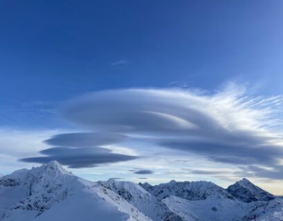
- Mountain wave turbulence. It is formed when a stable mass of air moves across a mountain range. Favorable conditions for the formation of a mountain wave are the wind speed blowing perpendicular to the mountains above 25 KT (over 46 km/h) and temperature inversion near the summits (up to 600 m above them). Of course, a mountain wave can occur when the wind direction is not exactly perpendicular to the mountain range. However, this phenomenon is most intense with strong wind, as perpendicular to the mountains as possible. Extreme turbulence and fast vertical flows – both downwards and upwards are dangerous characteristics of this phenomenon. All of this occurs on the leeward side of the mountains. Under favorable circumstances, strong vertical flows can reach up to 21,000 m (70,000 FT), and the horizontal range of the downdrafts itself can be up to 500 km on the leeward side of the mountains. The occurrence of a mountain wave may be indicated by the presence of Altocumulus lenticularis clouds in the sky in the form of characteristic lenses.
- Clear Air Turbulence (CAT). This term describes turbulence with a high-intensity dispersion – from a few annoying small shocks to very intense throwing/jerking, which presents a risk to the aircraft structure and the health of the crew and passengers. This turbulence differs from thermal and dynamic turbulence in that it is more regular. CAT is most commonly occurs at altitudes above 4500 m (15,000 FT). It is associated with significant changes in wind speed or temperature – both height (vertical wind shear) and horizontal changes of these parameters (horizontal wind shear). We can expect the strongest CAT turbulence near the jet streams in the upper troposphere.
In the operational work of the aviation forecaster, turbulence is defined as:
- Moderate – thermal or mechanical occurs when the substrate is very diverse within the range of Cumulus Congestus and Cumulonimbus clouds, up to 150 km from the mountain wave and weakly expressed stream jets. It causes frequent jerking and swaying of aircraft, a change of height by 30-50 m, and a speed reduction to 50 km/h.
- Severe – it occurs within the range of developed TCu clouds – Towering Cumulus (Cumulus congestus) and Cumulonimbus, and within the range of mountain wave and jet streams. It causes strong vibrations and tosses of the aircraft, rapid altitude changes, and frequent and sudden overloads that hinder pilotage. The height change during this phenomenon reaches more than 50 m, and the speed can be reduced to 50-80 km/h.
The task of an aviation forecaster is to forecast turbulence and issue warnings if the phenomenon is moderate or severe – following the adopted criteria and procedures. Note that many forecasts or warnings do not take into account the turbulence related to convective clouds. It is assumed that the dynamics of the updraft and downdraft currents is strong enough to accompany all Cu, TCu, and Cb clouds; of course, its intensity depends on the stage of cloud development.
Wind issues are one of the toughest to forecast. The best forecasts accuracy is obtained for wind direction and speed. Forecasting gusts, wind shear, and turbulence is a more significant challenge. These are momentary, point-based phenomena, forecasted on the basis of favorable conditions for their occurrence, resulting primarily from a specific baric situation. The exact timing and location of these phenomena and their strength are often unpredictable, making them extremely dangerous.
Maciej Benedyk, Maciej Zaborowski, IMGW-PIB/Civil Aviation Meteorological Protection Centre
Main photo: Owen Lystrup | Unplash