Modern satellite observations offer unprecedented possibilities for local (regional) and global agriculture monitoring.They allow imaging the Earth’s surface with a spatial resolution of 10-20 meters and a repetition time of 1-2 days*.Today, such satellite monitoring is primarily carried out by Sentinel-2, but the information it collects is a continuation of previous satellite systems used for agriculture, such as Landsat.The products of these programs, in the form of photos and images, are already available under the sat4envi project, led by the IMGW-PIB.
AUTHORS:
Elżbieta Kuligowska, IMGW-PIB/Department of Satellite Remote Sensing
Bartosz Wieczorek, IMGW-PIB/Department of Satellite Remote Sensing
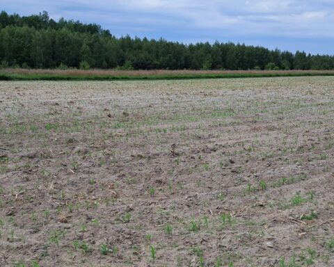
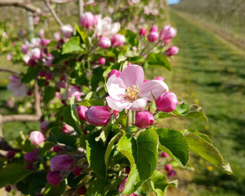
Data from the Sentinel-2 satellite enable the determination of soil properties and conditions for crops and the mapping of the current state of agricultural cultivation activities. All this information helps researchers and farmers to assess the usefulness of land, predict the quantity and quality of crops in a given period, monitor seasonal changes, and implement national or regional aid systems to implement sustainable development policies. The images from Sentinel-2 can also be used to estimate changes in agricultural production and pasture productivity, including those caused by drought, and monitor land productivity decline and soil degradation due to over-cultivation, grazing, or inadequate irrigation. Agricultural maps allow for independent and objective estimation of the range of crops in a given country or the duration of its growing season, which can be used to support activities aimed at ensuring food security in particularly sensitive areas.
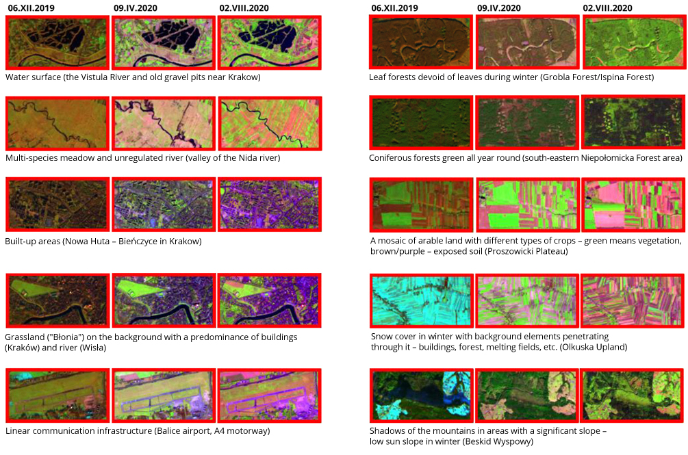
An example of a product helpful for this type of analysis is the RGB Agriculture colour composition created using the spectral channels of the MSI (Multispectral Instrument) sensor located on-board Sentinel-2 satellites. It is worth starting with that we are dealing here with a False Color type composition. It differs from the more „natural” True Colour compositions in that the image is created on the basis of colours conventionally assigned to the individual spectral channels registered by the satellite instrument. In addition, due to the use of near and mid-infrared part of spectrum, higher contrasts (spectral separation of the acquired image) are obtained, which facilitates the interpretation of data.
The RGB Agriculture colour composition allows for an accurate reproduction of the vegetation: the arable lands are clearly green, the bare land is purple, and the non-cultivated vegetation more subdued shades of green. The use of infrared light is not accidental because it makes it easier to track vegetation changes. In the early spring, arable/cultivated fields adopt a brighter green tone because they have a higher near-infrared reflectivity than the brown-toned deciduous forests where the leaves have not yet developed. This distinct contrast disappears over time as different types of deciduous vegetation are fully developed and adopt a light green colour. On the other hand, coniferous forests remain dark green all year round. This composition also clearly shows the differences between uncultivated farmlands and fields in the advanced stage of cultivation. Moreover, with the help of additional spectral channels, it is even possible to distinguish individual plant species. In the Agriculture composition, artificial elements of urban areas or communication routes are well determined, with low radiation reflectivity, so they are visible in violet or gray colours.
The presented examples of RGB Agriculture compositions were prepared by scientists from IMGW-PIB within the Sat4Envi project. The images were based on photos from the Sentinel-2 satellite collected in 2019-2020. The results of works for three different periods of the year were presented so as to obtain the greatest possible diversity of vegetation cover at various stages of its development cycle in winter (December 6, 2019), early spring (April 9, 2020), and summer (August 2, 2020).
Winter 2019
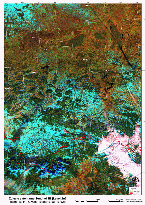
The photo from December 6, 2019, shows a very clear image of the snow cover in the Tatra Mountains and cultivated fields – shades of cyan and dark blue (the colour depends on the angle of illumination of the areas). Zakopane has a gray colour. As it moves north, the green and brown colours become dominant, these are forest areas. The colour is dark green in coniferous and brown in deciduous, although in this case it is very difficult to capture the differences in the colour composition of the leafless forest and moist, uncovered ground in the background. The range of natural and artificial water reservoirs – for example, Lake Dobczyckie – In dark blue colour is also clearly visible in the RGB Agriculture image. Big cities – including Krakow – are mainly gray and purple. There is not much snow here, but it appears in the uplands, in arable fields north to Krakow (in the vicinity of Skała and Słomniki, as well as near the runways of the Balice airport (east of Krakow). Despite the advanced winter, the grassy apron of the airport is also visible (light green), from which the runways stand out (urbanized areas, purple). A similar, although slightly more intense, green is also adopted by Błonia in Kraków, a large, triangular meadow near the city center. In Krakow itself, you can also see popular bathing areas: Bagry, Kryspinowski Reservoir, and Budzyński Reservoir.
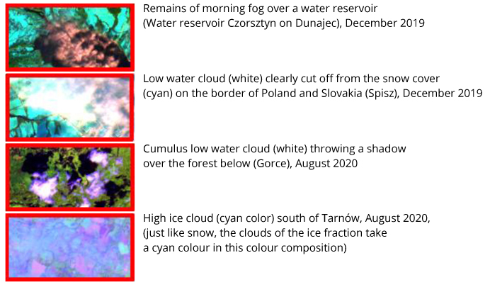
Due to the use of specific properties of radiation reflection in various spectral bands, we obtain the possibility of „extracting” a particular element of the image, which are clouds against the background of snow. In the visible light spectrum, both clouds and snow reflect very well solar radiation with the same wave range. For a person unfamiliar with the terrain’s topography (e.g., distribution of mountain ranges), these elements of the satellite image may be indistinguishable (cloud and snowmelt into a white area). By using RGB colour combinations such as „Agriculture,” we can distinguish the „whiteness” of a water cloud from the „whiteness” of snow by using a medium infrared channel (channel 11 for MSI Sentinel-2). This is possible because snow and ice absorb solar radiation in 1.6 µm band very strongly, while the water cloud reflects it.This specific characteristic distinguishes the low-lying cloud/fog in the mountain valleys (on the border of Poland and Slovakia in the south-eastern part of the characterized area) from areas free from cloudiness but with accumulated snow.
Spring 2020
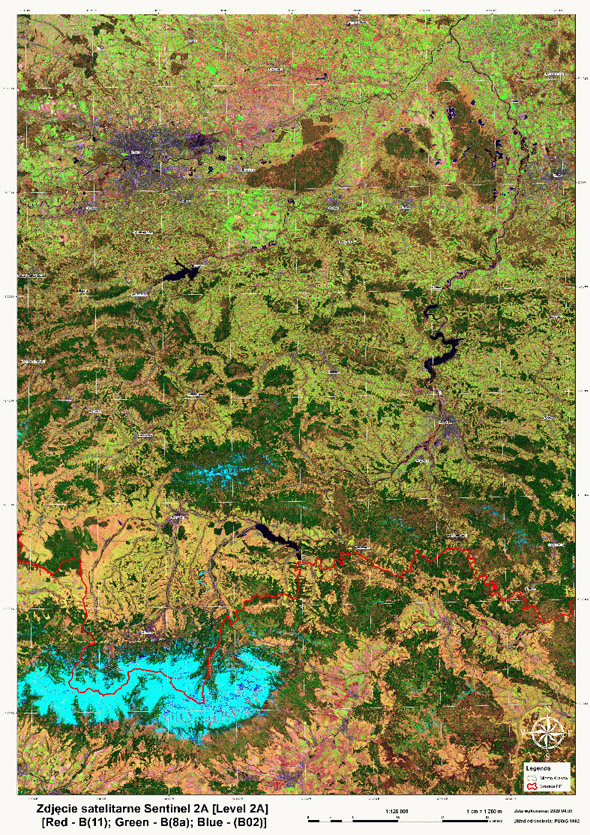
In the photo from April 9, 2020, the lack of snow is most noticeable – It occurs only in the upper mountains. The Tatra vegetation floors are mainly exposed, like the forests around Zakopane and Nowy Targ – dark green. The snow is still between Nowy Targ and Mszana Dolna in the Gorczański National Park (dark green forests and cyan corresponding to snow areas) – It can be seen, among others, on the Turbacz Massif. However, it is not found in the Niepołomice Forest (rotten-green colour); it has also completely disappeared from the vicinity of Krakow. Around Krakow and Proszowice, we can see both heavily built-up areas (purple/gray) and „empty” areas in shades of brown and pink – this is probably the soil lying on arable/cultivated fields. There are numerous areas with the beginning of plant vegetation in light green colours. In Krakow, for example, it is a small green square located north of Błonie – Jordan Park. The Krakow Wolski Forest, just like the Niepołomice Forest, is blooming – It has the colour of green mixed with brown. In this respect, it differs significantly from the dark green coniferous forests, proving that RGB Agriculture images perfectly emphasize the differences between individual plant species, in this case trees that dominate in a given area.
Summer 2020
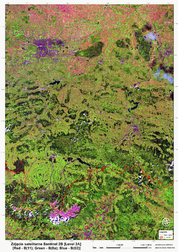
The last colour composition was created from the data recorded on August 2, 2020. It is almost the middle of summer – we can see that there is practically no snow in the Tatras anymore. On the highest peaks of the mountains, there is a characteristic colour – magenta – reflecting the exposed „naked” rocks in this colour composition. On the other hand, individual plant levels of high mountains are clearly visible, as well as single, long and dark shadows, white cumulus clouds over the Tatra Mountains. Clouds also appear over the Gorce and around Tarnów. As in the description of the image concerning the winter period, we can also describe the type of visible cloudiness by its colour. Low-floor water clouds, such as the small cumulus clouds visible over the Tatras, Gorce, and other higher parts of the mountains, are white. Clouds on the high floor, like the clouds visible in the vicinity of Tarnów, made of tiny ice crystals, are cyan.
It is green around Zakopane – there are pastures here, but there are not many cultivated fields. The Niepołomicka Forest and the Wolski Forest have become more mature, more intense colors of green – the trees are covered with leaves. Apparently, the area around Krakow has been affected by drought, the grass at the Balice airport and even in part of Jordan and Błonie Park is brown. Brown and pink stains north of Krakow also attract attention – these are arable fields where crops have already been harvested. There are also many areas with bare soil (light purple) – there is also already after the harvest. Thus, there are not many cultivated plants still growing at this time of the year, but these fields are not hard to find – in the photo, they are shown in light green colours. The gray-purple „veins” are built-up and urban areas, concentrating along the river valleys.
How to read RGB Agriculture images
* The time-frequency of 1-2 days refers to the acquisition of images in spatial resolution [10-20 m] for areas monitored by all ESA Copernicus satellites of the Sentinel-1 mission [descending and ascending path] and the Sentinel-2 mission [only descending path]. For the vast majority of Poland’s territory (over 80% of the country’s surface area), the frequency of acquiring images only from the satellites of the Sentinel-2 mission is 2-3 days.
Main photo: Adele Payman | Unsplash.