The Unified Model (UM) is one of the first numerical weather prediction models launched in Poland, regularly providing weather forecasts until today. It was developed by the UK Met Office (UKMO) meteorological service, where it has been operating since 1991.
AUTHOR: Leszek Herman-Iżycki, Interdisciplinary Centre for Mathematical and Computational Modelling (ICM), University of Warsaw
In the 1960s, numerical weather and climate forecasting were treated separately. And while in the area of climate issues, the need for a global approach was understood from the very beginning, weather models at that time were counted for a short period and in a limited area.
The first global weather prediction model was developed in the late 1970s and was modelled on the climate model from which it used advanced parameterisations of physical processes. However, an integration scheme was then newly developed for rapid calculations. As a result, in the 1980s, two global models – climate and weather, were used in the UK Met Office meteorological service. In addition, a non-hydrostatic local model covering the UK area was in operational use. These models were developed separately as they had different objectives.
Global models were written in a language-specific for the CDC CYBER 205 computer. Due to the costs and time of transferring the code to new computing machines, it was necessary to unify the models. The final impetus for this decision was the withdrawal of Control Data Corporation from supplying the successor to the CYBER 205 supercomputer[i]. In such circumstances, the Unified Model was created within two years, which could be used to forecast both climate and weather – in a global configuration and in a limited area. The model was written in Fortran with a little addition of machine-specific low-level instructions. The configuration of the model was defined in the control files in such a way that, so far, different models used different settings and one code. UM was launched operationally in the global version in June 1991, and in the mesoscale version – in a limited area – it was started at the end of 1992[ii].
The beginning of the numerical weather prediction (NWP) in Poland. At the same time, i.e. in the early 1990s, numerical weather prediction in the mesoscale version was not yet available in Poland. In the study „The IMGW Numerical Weather Prediction System based on the source code of the Unified Model of the British Meteorological Office”,[iii] the following was written: „The issue of developing the Institute’s own numerical weather prediction system is a challenge for the Institute, and every effort should be made to implement it as soon as possible and at an appropriate level „and: „At the IMGW, the basic argument for not undertaking work in the field of the NWP was the lack of an appropriate computer for calculations.”
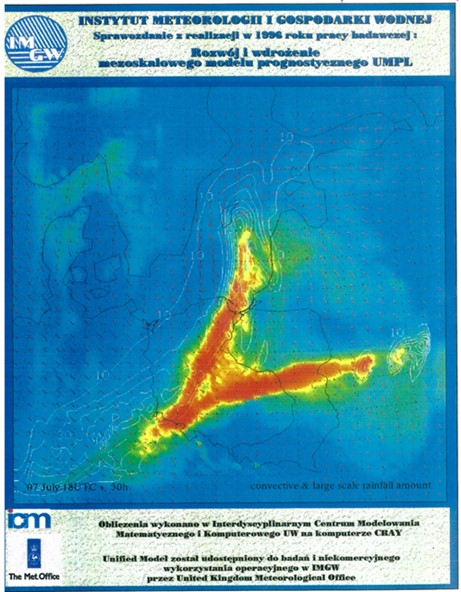
Attempts to build the NWP (Numerical Weather Prediction) system at the Institute were undertaken by Dr Bogumił Jakubiak, head of IMGW’s Long-range Forecasting Department. He used the fact of establishing a new unit at the University of Warsaw – the Interdisciplinary Centre for Mathematical and Computational Modelling (ICM UW), where the first supercomputer in Poland was installed. It was an 8-processor Cray EL-98. Jakubiak chose the UM model for the needs of the numerical prediction system. An important circumstance was that the supercomputer for ICM was provided by Cray, which also equipped the Met Office with its Cray YMP-8 and Cray C90 computers. It facilitated the subsequent installation of the code: the UM version launched in 1997 on the Cray YMP-4E machine was compiled on the Cray C90 in the Met Office.
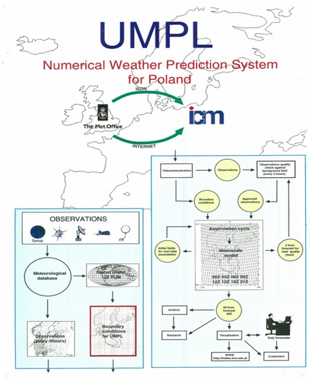
Launch of the UM model at ICM UW. In June 1994, in consultation with the Met Office, Dr Jakubiak installed the UM model in version 3.2 on the ICM computer. In October, a licence for the mesoscale version was obtained for research purposes. However, the global version had to be used as a source of boundary conditions and an initial condition for the mesoscale model. The global model was run in the N144 version (288×217 grid, resolution approximately 90 km at medium latitudes) at 19 levels for 36 hours. The regional model was computed on a rotated pole grid so that the equator intersected the centre of the computational domain. The grid was 92×92 horizontally and 30 levels high. The mesh resolution was a 0.15-degree square, so the horizontal resolution was about 17 km. The vertical coordinate was hybrid. The model levels followed the ground surface up to a certain height, and the other levels were at a constant height above sea level. The model equations were in the hydrostatic approximation.
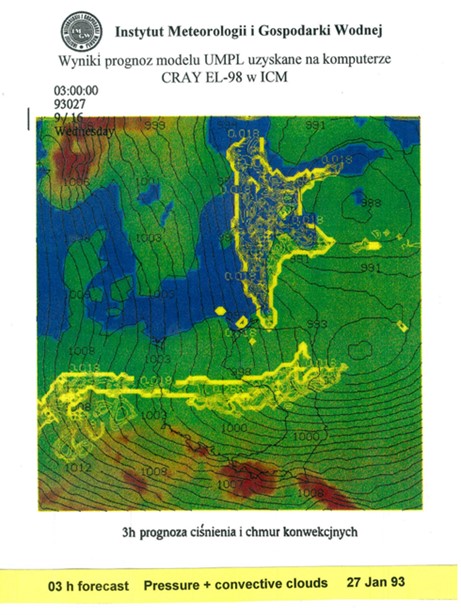
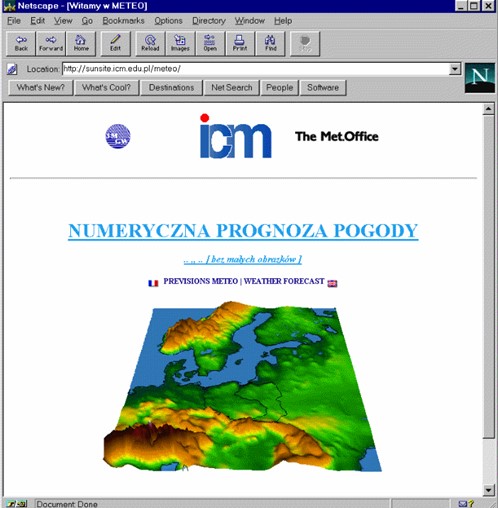
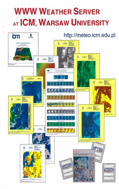
The model was tested until mid-1996, covering the period 25-28 January 1993. The experiment results were promising, so the next step was to test run the model in quasi-operational mode. The regional model over Poland was fed by the model calculated in the Met Office. The boundary and initial data were sent daily from the Met Office to the ICM via an internet connection. The model results were published on the Internet, on a dedicated website. The quasi-operational test lasted three months (from November 1996 to January 1997). The forecast was calculated once a day, 36 hours ahead.
The experiment showed the technical possibilities of launching a numerical forecasting system at IMGW in cooperation with a foreign partner using the ICM infrastructure. At that time, the new Cray YMP-4E computer was already installed in ICM, on which the UM model was also run. Despite these positive experiences, no bilateral agreement between the Met Office and the IMGW was reached. One of the reasons for the failure of building the NWP system using the UM model was probably the licensing costs that the Institute would have to incur. In this situation, the director of ICM, Prof. Marek Niezgódka, engaged a team from IMGW, and calculated numerical forecasts in cooperation with the Met Office.
May 1997, model restart. After modifying the settings, the Unified Model was updated to version 4.0. The computational domain of the model was extended to include the Baltic Sea area. The new computational grid had a size of 144×116 with the previous resolution of 0.15 degree of mesh resolution. The model was run with the assimilation of observational data so that it used its own forecast, modified as a result of assimilation, as a starting field. It contributed to the improvement of the forecast results. Observational data were provided eight times a day. Therefore the model was run eight times a day in an assimilation cycle. The forecast length was extended to 48 hours. The boundary conditions provided were from the regional model at 18.00 UTC, the second model in the cascade of models. This model was nested in the global model N144 at 12.00 UTC. The obtained boundary conditions included the forecast from T + 3 to T + 54 with a 3-hour step to cover the data assimilation period from the 3rd hour before the nominal forecast start and the 48-hour forecast.
In February of the following year, the model performing computations was changed. It was the global model N216 on a 432 × 325 grid with a resolution of about 60 km at mid-latitudes. The boundary conditions were extended by 24 hours so that possible transmission problems do not block the calculation of the next forecast. A forecast from T + 9 to T + 84 was provided with a 3-hour step. These extended boundary conditions allowed for the gradual launching of forecasts starting at times other than 00 UTC in the following months.
The publication of the numerical weather forecast results was a novelty at that time. Initially, only maps of selected weather elements were available. Later, the service was supplemented with the first in Poland meteorograms, as well as overview maps showing several elements at the same time. A video in MPEG format was made available showing the forecast hour by hour. The forecast was published in „Gazeta Wyborcza” and presented in a dynamic form on TVP in the morning programme „Kawa czy Herbata”.
Cooperation with IMGW. From the beginning of the meteo team at ICM, contacts with the Institute of Meteorology and Water Management were maintained with varying intensity. Although the activities of both units could potentially be complementary, and the forecasts from the UM model used by IMGW for the current assessment of the meteorological situation, an agreement on this issue was only concluded in December 2016. At the turn of the century, the activity of the meteo team was perceived rather as competition in meteorological forecasting. At the same time, IMGW representatives favoured applying the French ALADIN model, with the use of which the first numerical forecasts at the Institute were developed in 1998. ICM UW continued work on the British Model. Because IMGW did not agree that ICM UW should use the term “weather forecast”, the meteo.pl team used the terminology “numerical weather prediction” (“numerical weather prediction” was not approved by IMGW forecasters).
At the end of the 1990s, Poland experienced heavy rainfall, causing floods, resulting in loss of life and enormous material damage. Some of the NWPs that ICM UW developed then were highly verifiable, while others failed. After one of such unsuccessful forecasts, IMGW published a message signed by the IMGW Deputy Director for Meteorological Forecasts, Ryszard Klejnowski (currently one of the weather forecasters at ICM), in which he „informs that he is not responsible for the actual and potential effects of forecasts and warnings prepared and provided by […] ICM UW to state and local authorities and institutions, as well as published in the media and on the Internet”[iv]. Undoubtedly, attempts made at the time by ICM to interest state authorities in building an „early warning system in which the information obtained from the model would help in making decisions” – as the ICM UW Director wrote in reply to the IMGW communiqué – were not well received by the Institute’s management and resulted in a lack of cooperation between the units for the next several years.
Incorrect forecasts became an impulse to supplement the service with a forecaster commentary. It was intended to be a synoptic verification of the published numerical weather forecast, but over time the comment evolved towards a synoptic evaluation of the current and forecast weather. Currently, the commentary is not only a broader analysis of the forecast but also a valuable source of knowledge about meteorological phenomena.
In December 2016, the then directors of ICM UW and IMGW-PIB, Prof. Marek Niezgódka and Dr Przemysław Łagodzki, signed a cooperation agreement „in order to constantly strive to improve the quality of meteorological protection”. Based on this agreement, ICM UW provides the IMGW-PIB with current forecasts from the 4 km resolution UM model in operational mode to use forecasts for the statutory activities of the Institute.
UM model in the 21st century. In the following years, the forecast was prepared more than once a day and finally – since July 2001 – It was prepared four times a day. At the beginning of 2003, it was extended to 60 hours. The UM model in the hydrostatic version with continuous data assimilation was operated at ICM until 7 October 2008. At the time of deactivation, the UM model was outdated. In the Met Office in 2002, the model in version 5.x was launched (the operating version is 5.2), and the „new dynamics” was introduced. It was a semi-Lagrange dynamics in a non-hydrostatic formulation. At the same time, many physical parameterisations were changed in the model.
In ICM, the model with new dynamics was run in version 6.0 and later in version 8.5. The most significant configuration modification was the change of the model resolution from 17 km to 4 km and increased the resolution vertically to 38 levels. The forecast counting system was completely rebuilt. The assimilation of observational data was turned off, which meant that each forecast required a leading model to provide a starting field. The generation of boundary conditions was moved from the Met Office to the ICM. The initial and boundary condition used for simulation came from the same forecast in the leading model.
Previously, the boundary conditions were changed once a day. Now they were supplied four times a day. Each forecast became an independent process, to which data was provided by the model performing computations run in the Met Office. Data assimilation was only carried on a leading model. Such a setting of calculations had a negative impact on the quality of the first dozen hours of the forecast, especially the correctness of convective precipitation forecasting. In 2012, the UM model started to use additional fields at its intended resolution. These are sea surface temperature (SST), sea ice cover, land snow cover, and soil moisture parameters. These data come from models calculated in Met Office – OSTIA (Operational Sea Surface Temperature and Sea Ice Analysis) and SURF (Land Surface Data Assimilation). In this setting, the model works until today.
The model providing data to the ICM tool varied depending on the resolution of the global model and the Met Office regional models nested within it. The launch dates of the global models in the UK service are shown below, together with their spatial resolutions:
● 2005, N320 global model on a 640×480 grid (~40 km) and 50 levels;
● 2009, the number of levels changed to 70;
● 2010, N512 model on a 1024×769 grid (~25 km);
● 2014, N768 model on a 1536×1152 grid (~17 km);
● 2017, N1280 model on a 2560×1920 grid (~10 km), operating at this resolution until now.
The UM model at ICM led the global model or the NAE (North Atlantic & European) regional model, calculated initially at 20 km resolution and since 2005 at 12 km resolution. The current configuration of the UM model calculated at ICM is modelled on EURO4, which has a resolution of about 4 km (similar to the model resolution at ICM) and is run in the Met Office also without assimilation. Another UM model launched at ICM was a model with a new resolution of 1.5 km in the centre of the computing domain, 4 km at its boundary, and 38 altitude levels. The model grid is 1472×1024. The computational domain of the new model is the same as that of the 4 km model. The model is also fed with the same data, except for the extra fields it receives at its own resolution. The variable grid model is currently counted operationally twice a day for 78 hours ahead for starts at 00.00 and 12.00 UTC.
In 2014, UM received a new dynamic kernel (UM 10.x) – the so-called Even New Dynamics – ENDGame. At ICM, a new version started to be used in 2017. At the same time, UM models (both 4 km and 1.5 km) began to be counted in a vertical resolution of 70 levels with a preserved altitude of the atmosphere up to 40 km. In the summer of 2019, the forecast length was extended. Currently, the model with a resolution of 4 km is counted twice a day (at 00 and 12 UTC) for 120 hours. The results of the extended forecasts are available on the website mapa.meteo.pl.
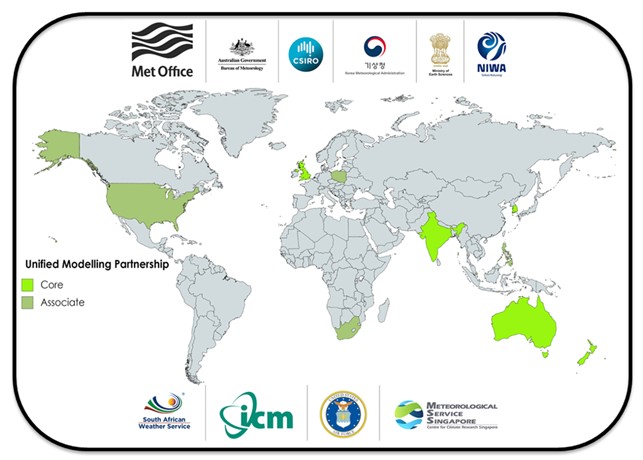
The UM model is used as operational by many meteorological and other services. It is run both in a global version and in a Limited Area Model (LAM) or LAM only (as in ICM). In the case of the LAM version, the UM model (global version) is usually also the leading model, although another model, such as ECMWF, may be used (as is the case in Singapore in MSS). Organisations using the UM model are members of the Unified Model consortium established by the Met Office.[v] ICM has been its associate partner since 2015.
[i] https://doi.org/10.1007/978-3-642-84020-3_8.
[ii] http://dx.doi.org/10.1175/BAMS-D-12-00018.1.
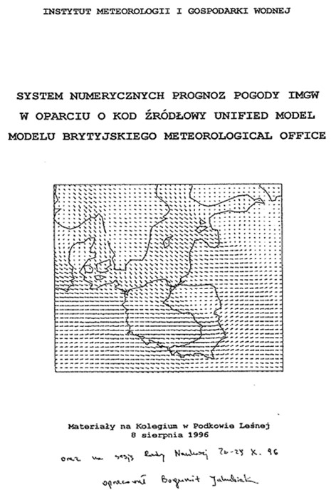
[iii] B. Jakubiak, 1996, IMGW numerical weather prediction based on the source code of the Unified Model of the British Meteorological Office, [in:] Materials for the Collegium in Podkowa Leśna, 8 August 1996 and for the sessions of the Scientific Council, 28-29 October 1996.
[iv] „Gazeta Wyborcza”, 29 July 1998.
[v] https://www.metoffice.gov.uk/research/approach/collaboration/unified-model/partnership.
Author: Leszek Herman-Iżycki | Interdisciplinary Centre for Mathematical and Computational Modelling (ICM), University of Warsaw.
Main photo: Johannes Plenio | Unsplash.